4/17/2025
Unraveling the World of Maps: A Journey Through Time
Maps have been part of human civilization for THOUSANDS of years. They are more than just representations of land; they are vital tools for navigation, exploration, and even storytelling. So let’s unravel the intricate history & evolution of maps, their significance in modern society, and the transformative technologies that have revolutionized cartography.
The Historical Significance of Maps
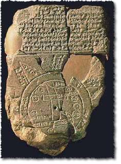
Maps have evolved dramatically, reflecting the rich culture & intellect of past civilizations. The earliest maps can be traced back to ANCIENT cultures like the Babylonians, who used clay tablets to represent their world circa 600 BC. Celebrated maps, like the famous Babylonian tablet map, showcased geographic features like rivers & mountains, with Babylon at its center, demonstrating the human fascination with the landscape surrounding them.
Fast forward to the age of exploration in the 15th and 16th centuries, where explorers like Christopher Columbus & Ferdinand Magellan relied heavily on maps to navigate uncharted territories. This era marked a monumental leap in map-making, with cartographers like Gerardus Mercator developing projection techniques that allowed for accurate Qrepresentations of the Earth’s curved surface on flat maps, laying a critical foundation for modern mapping.
Advancements in Map Technology
As we transitioned into the 19th & 20th centuries, mapping technology experienced groundbreaking advancements.
Aerial Photography
The emergence of aerial photography transformed how we perceive maps. French photographer Gaspard-Félix Tournachon, known as Nadar, captured the first aerial photograph from a hot air balloon in 1858, giving cartographers the ability to create detailed maps from above.
The Digital Revolution: GIS & GPS
The real game-changer, however, came with the advent of Geographic Information Systems (GIS) and Global Positioning Systems (GPS) during the late 20th century. GIS technology allowed researchers & planners to analyze complex spatial data in ways previously impossible. It turned maps into dynamic, interactive tools capable of integrating various layers of information, from population density to environmental data.
Furthermore, GPS, originally developed for military purposes, has become an everyday necessity for civilians. Nowadays, we can find our way using just a smartphone, making navigation & exploring easier than ever. The technology is so advanced that it can pinpoint our location within mere meters, making the uncertainty of getting lost a thing of the past!
The Role of Maps in Modern Society
Maps in Education
Maps serve as EDUCATIONAL tools, aiding in the teaching of geography & history. They help students visualize spatial relationships, promoting deep understanding of the world they inhabit. Google Earth Education, for instance, offers ways to explore the planet, trace journeys, & even analyze environmental changes over time through interactive mapping tools.
The Rise of Digital Mapping Tools
The rise of digital mapping tools has made map creation accessible to a wider audience. Platforms like Mapbox & ArcGIS enable users to create customized, interactive maps for various purposes without needing advanced coding skills. This democratization of mapping has sparked creativity & expanded the ways we use maps, making them indispensable in industries such as real estate, urban planning, & EVEN social activism.
The PRactical Applications of Maps
Local businesses and influencers are increasingly using maps for marketing & navigation. By embedding maps on their websites, they can guide customers to their doorsteps or highlight special events. Not only that, maps help improve user engagement by offering personalized experiences! This brings us nicely to our next point.
Enhancing Engagement with Arsturn
With the power of Arsturn, brands can build custom AI chatbots that engage audiences before they even arrive at your site. Arsturn's platform makes the chatbot creation process incredibly easy: Design your chatbot effortlessly to fit your brand. From there, train it on specific data, & watch as it interactively engages your visitors, answering questions based on your website's content without the need for extensive coding knowledge.
Whether you're an influencer, a local business owner, or managing educational resources, Arsturn allows you to streamline operations, connect effectively with your audience, & offer instant information. Transform how you engage with the online community while saving time & cost in development.
Get started with a FREE version of Arsturn today & elevate your audience's experience!
The Future of Cartography
We’re on the verge of a new era in mapping, powered by advancements in machine learning & artificial intelligence. The rise of augmented reality (AR) & virtual reality (VR) mapping technologies promises to transform our interaction with geographic data.
Imagine navigating your city NOT just with GPS, but through immersive VR experiences where you can see all relevant information overlaid on your current location! Companies like Living Map are at the forefront of these innovations, providing indoor wayfinding solutions that adapt in real-time to user movements & engagement patterns.
Conclusion
Maps are indispensable in our increasingly interconnected & complex world. They demonstrate not just geographic locations but embody a story of our quest to understand our environment. With the ongoing innovative developments in mapping technology—be that through digital tools, GIS, or conversational AI platforms like Arsturn—the potential for how we can use maps is limitless.
So, whether you’re a casual user finding your way around town or a business seeking to enhance customer engagement, maps are your canvas for exploration, learning, & connection.
Join the journey of map-making today, engage with your audience, & transform how you navigate the world around you.
Discover the power of mapping with Arsturn. 👉 Arsturn.com
---
Future Blogs to Explore
- The Impact of Mapping in Climate Change
- GPS Technology: The Heart of Modern Navigation
- Exploring Cultural Maps Throughout History
- How AR is Transforming Spatial Navigation